
I was hoping I’d get lucky.
Victoria’s East Gippsland region was burning with bushfires that would end up claiming lives and homes and devastate communities.
But they were nowhere near where I’d planned a five-day walk from Harrietville to Falls Creek in the Alpine National Park after Christmas.
Keeping a close eye on the weather forecast and the Victoria Emergency app, there were no fires in the park and the forecast seemed to have settled down a bit when I set out (Tuesday, New Year’s Eve).
Heading up Bungalow Spur to Federation Hut and Mount Feathertop, dark clouds gathered overhead and there was a steady rumble of thunder. A few short showers passed, but nothing significant. My sweat from the climb soaked my shirt more than the rain.
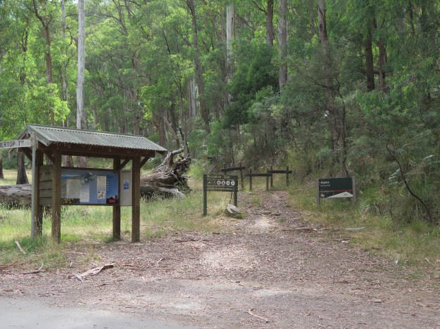
Bungalow Spur trail head.
Whenever I stopped for a rest I checked the emergency app for reports of fires. (Thankfully there was phone coverage) There were concerns that dry lightning from the storms could spark fires in the area as they passed. Nothing was showing up.
I got to Federation Hut about 2pm after about four hours of walking, set up my tent and then set off to climb nearby Mount Feathertop and collect water from a spring (the water tank at the hut was empty).


Feathertop has spectacular 360 degree views across the entire region. And unfortunately, those views included puffs of smoke to the south-west. They were a fair way away and there was a lot of country between me and them, but they would have to be watched. I listened to ABC Radio on my portable radio and it sounded like things were getting dire on the south coast. They also mentioned that dry lightning had sparked some fires in the Alpine area but there was little detail as the focus was on people and communities threatened by fire in the south.
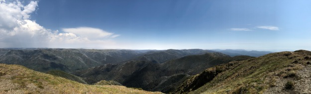
Panorama from the top of Mt Feathertop. Mt Hotham is about the middle of the picture, Falls Creek to the left a bit.
Back at Federation Hut and quite a few people were arriving and setting up camp. That gave me a bit of confidence that things couldn’t be too bad.
The next morning (Wednesday) dawned clear blue sky. The Emergency app showed there were a couple of fires south of Falls Creek, as well as the ones to the south-west. But there was no smoke in the air, the temperature was mild and there was little wind so I set out along The Razorback, heading for Mount Hotham, with Dibbins Hut my intended campsite.


When I got to Hotham I climbed to the summit, where there’s also an observation tower, and could clearly see smoke coming from fires south of Falls Creek. I asked the guy manning the tower what the fires were doing and he said “burning”. (Typical Aussie deadpan humour!) Even though there were a couple of rivers and valleys in between, they didn’t look that far away. It was decision time – continue walking another two days, in rugged country, in the direction of the fires, out of mobile phone coverage for some of that, or pull the pin. The guy said I could probably do it, but I’d be putting myself at risk.
I mulled it over as I walked down to the Mount Loch Car Park where the trailhead to Dibbins Hut begins and decided to stop there. Fires are too unpredictable. I’m a runner but there’s no way you can outrun a bushfire. And even if I was in danger and I set off my EPIRB, I don’t think rescue authorities would be very impressed with coming for me – if they even had the resources available to do so.
So I rang my wife and said I was quitting the walk. I stuck out my thumb and hitched a lift back down to Harrietville with a couple who had evacuated from their home near Omeo because of the fires and were on their way to a relief centre.
While disappointing, my decision to stop was vindicated the next day (Thursday) when Watch and Act Advices (basically a recommendation to leave) covering the area I was in were issued. By Friday (my planned last day), they were upgraded to Evacuate.
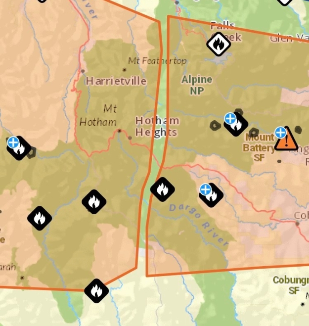
Screen shot of the Victorian Emergency app showing the areas covered by the Watch and Act advice and where the fires were.
I’ll try this walk again one day. Hopefully the fires don’t take everything in the meantime. But with climate change and the Australian Liberal/National government refusing to address it, that may be an unrealistic dream.

Hi Gavin! Happy new year. I’m so glad you got out of there!! These fires are scary. Not worth the risk.
The hikes will hopefully still be there.
Sent from my iPhone
>
Definitely the right decision to pull out. Fire is too unpredictable, and too many families have lost too much already this summer.
Pingback: Bogong High Plains circuit hike | The Outdoorsy Type